
 While visiting some friends in Boise, Idaho they suggested taking a drive on the incredible Payette River Scenic Byway. It was September of 2020, it was a beautiful day, and we were definitely ready to see some natural beauty. We loaded up our convertible Beatle rental car and headed out for a few hours. They suggested we allow about 2 and 1/2 hours and they were right, however, we took even longer stopping MANY times along the way. I think we were gone almost 5-6 hours, lol Below is a video of some of the places we saw on our drive along the river.
For those of you who had not heard of the Payette River Scenic Byway, like us, I will share a little bit about the river and the area. It is 112 miles running between the greater Boise and New Meadows in Idaho, and spans 4 counties. Along the route, the byway accesses thousands of miles of recreational trails, whitewater, mountain vistas, and opportunities for wining, dining, and family fun. Great stops along this drive include Kelly’s Whitewater Park, Lake Cascade State Park, Smiths Ferry, Roseberry (one mile east of the byway on Roseberry Road at Donnelly), the city of McCall, and Ponderosa State Park. It was designated an Idaho Scenic Byway in June 1977, and a National Scenic Byway on June 13, 2002.
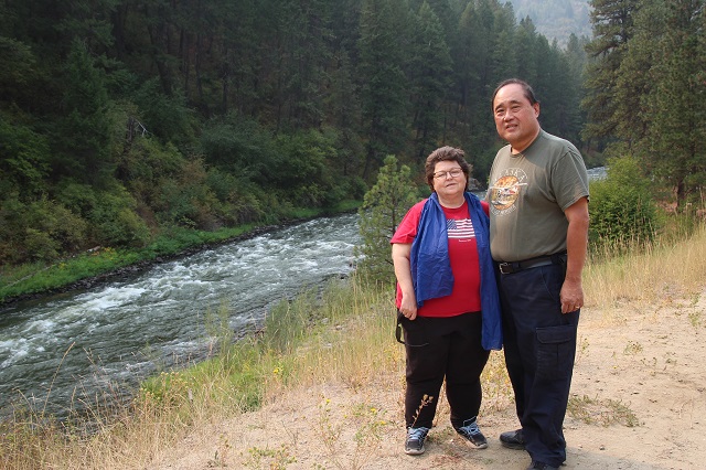
 It was so easy to get distracted and try to see everything at once along the route, but they have many pullouts to access the river and some beautiful spots to stop, smell the fresh air, and watch the wildlife. The only thing different we saw on our trip was a few bluebirds. They were really cool and interesting to see. Mostly I was surprised at how fast the water was running in some areas, especially since it was September. I wouldn’t have been surprised earlier with snowmelt and such, but happily surprised to see it still running wild. 🙂 Definitely some beautiful whitewater.
 The Payette River is classified as a Class V run, and some experts call it the most challenging river reaches in North America, if not the world. The North Fork narrows and drops about 1700 feet in 16 miles which provides nearly endless Class V rapids. I have never been White River Rafting, but I share some of the ones that seem amazing to me on the link above. The Payette River would definitely NOT be my first attempt at rafting, lol.
 The Payette River originates in the Sawtooth and Salmon River Mountains with elevations over 10,000 feet (3,000 m). The drainage then flows primarily from east to west, with the cumulative stream length to the head of the North Fork Payette River being 180 miles (290 km). Meanwhile the head of the South Fork the cumulative length is nearly 163 miles (262 km)/ Then the combined Payette River flows into an agricultural valley and empties into the Snake River near the city of Payette at an elevation of 2,125 feet (648 m). With that said, the Payette River’s drainage basin comprises about 3,240 square miles (8,400 km2). Wow, that is all I can say, lol.
 We enjoyed more just driving around in our little convertible, stopping along the way to have lunch while enjoying the views, and pulling out at many stops to take in the beauty, as well as take a few pictures. I thought I really enjoyed the Peak to Peak Trail here in CO, but there is nothing like following a rapidly flowing river. It was incredible. I look forward to the next time we are in the area to do some more exploring.

Directions:

From Boise, head north on Idaho Highway 55 to the junction of U.S. Highway 95 in New Meadows.
 State Highway 55 (SH-55) is an Idaho highway from Marsing to New Meadows, connecting with US-95 at both ends. From Marsing it travels east to Nampa, Meridian, and Eagle, then north to Horseshoe Bend. SH-55 then climbs the Payette River to Banks, then it forks north to the Long Valley, through the towns of Cascade and McCall. After descending a narrow canyon to Meadows, SH-55 terminates in New Meadows at the junction with US-95.
Highlights along the byway include:
- Eagle Sports Park,
- Payette River access,
- Kelly’s Whitewater Park,
- Lake Cascade State Park,
- Tamarack Resort,
- Historic Roseberry Townsite,
- Payette Lake,
- Ponderosa State Park,
- Legacy Park,
- Central Idaho Historical Museum,
- Brundage Mountain Resort,
- Dorsey Warr Park,
- Little Ski Hill,
- Jug Mountain Ranch,
- Burgdorf Hotsprings,
- Gold Fork Hotsprings,
- Historic P&IN Railway Depot

LIKE WHAT YOU ARE READING?

I would love to send you my free travel itinerary cheat sheets and emails when I post new articles! I usually post 2 times a week. Sign up now, receive your free travel sheets, and don’t miss an article. Thanks, Samantha


This post was created using WordPress. Create your own site for FREE!