Phoenix Gold Mine Tour – Idaho Springs, Colorado

Phoenix Gold Mine - EntranceA couple of years ago we only had a few days for our anniversary so we spent a long weekend in Idaho Springs here in CO. It’s only an hour or so away and was a nice but short getaway. While in the area we decided to a tour of the Phoenix Gold Mine. We had been to a few cave tours like Carlsbad Caverns in NM, but never a gold mine. This was new and different for both of us, and we were excited for our tour.

Phoenix Gold Mine - 5I am going to share a little history about the mine before I share our experience. According to their website, the Phoenix Gold Mine is a family business was purchased in 1868 by their family of 4th generation Colorado Miners. They estimate that the mine has produced over 100,000 troy ounces of gold. For those of you who didn’t know, like me, one troy ounce is equal to 1.097 standard ounces.

Phoenix Gold Mine - 1In 1988 they decided to share their passion for prospecting, mining, and panning for gold with others by offering tours. During the tours they talk about geology, history, and mining equipment. You will see 2 different gold veins (gold in its natural setting). Both gold veins are beautiful and quite different because of their mineral content. You will learn about how gold is extracted from the rock and processed to its pure form in our underground mill. It is quite an interesting process.

Phoenix Gold Mine - 2The day of our tour we got there a little early and waited while the group in front of us finished their tour. We met some of the people that were going to tour with us and were given these fancy hard hats to wear during the tour. You can see our group all ready to go in the picture below.

Phoenix Gold Mine - USOur tour guide was not only a guide, but one of the owners. Not surprisingly he was very informative and knew everything about the mine and its working. He explained things in a way that we could understand and really appreciate the impact they have had here in Colorado and area. I felt we were very lucky to have him lead us around and answer any questions we had.

Phoenix Gold Mine - 3Sadly I don’t remember all the stories he shared, but he was definitely entertaining and I highly suggest doing your own tour and see what you can learn and maybe go home with a trinket of gold if you wish to try your luck at panning for gold.

Phoenix Gold Mine - 4Tours are given on the hour and each tour is about 1 hour. Tours include a hands-on gold panning lesson with our combo package. Things to note, tours consist of less than 500 feet of walking, but temperature is approximately 45 degrees Fahrenheit. A light jacket or sweatshirt is recommended. One other thing, the Phoenix Mine Company is also dog friendly and more than happy to accommodate your furry friend(s) as long as they are on a leash, get along with other dogs, and are comfortable around other people.

Phoenix Gold Mine - 6We had a great time touring the mine and definitely learned a lot. If you are in the area, I highly suggest doing a mine tour, especially the Phoenix Gold Mine. Here is a link to their website. You won’t be disappointed. Please drop a comment if you have been on this tour or a similar tour. Would love to hear about your experience. Happy Travels.

Phoenix Gold Mine Visitor Information

Address:

800 Trail Creek Road – Idaho Springs, CO 80452

Phone:

303-567-0422

Hours:

Monday thru Friday 10 am – 4 pm
(Reservations  required for the 4pm tour)

Prices:

$25 Adults (17- 64)
$20 Children (4-16)
FREE Babies (0-3)
$20 Seniors (65+) & Veterans (show ID)
15% Clear Creek County Residents (show ID)

Directions:

Take US-6 W and I-70 W to 3rd Ave in Idaho Springs. Take exit 239 from I-70 W. 

Parking:

Free

Accessibility:

Q: What is the accessibility for someone physically challenged?

A: Tunnel openings are wide; the pathways are mostly flat with ore car rail. There are no steps. Some can navigate the path with crutches or a walker. Manual wheelchairs have been accommodated with extra assistance. Please call ahead & they will be happy to assist.

Gold Panning Lesson

A: They can provide a stool or chair to sit on during the panning lesson if you ask for one beforehand.​

Parking

A: They have a few handicapped parking spaces available beside the gift shop which is located near the mine entrance. Parking lot is covered with gravel. If Creekside Panning is open, you may also park alongside the road by the panning building for easy access to gold panning (please let one of their staff members know that you are parked there).


Junction Bridge and Riverfront Park – Little Rock, Arkansas

Junction Bridge - 1
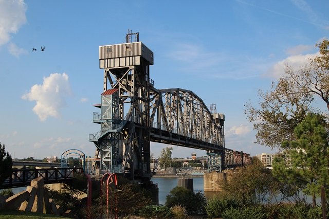
While in Little Rock, Arkansas we did a lot of exploring, and enjoyed checking out the Arkansas River. One of the cool things we saw was the Junction Bridge near the Clinton Presidential Library. Originally built as a railroad bridge in 1884, Junction Bridge was then rebuilt in the 1970’s and was eventually converted into a pedestrian bridge in 2008. It is a life-span bridge crossing the Arkansas River and ties together the towns of Little Rock and North Little Rock.

Junction Bridge - 3This $5.8 million rehab project resulted in the 360-foot lift span being permanently fixed at thirty-eight feet above the river, with access provided by stairs or a glass-enclosed elevator. About eighty percent of the project was supplied by federal funds, with Little Rock, North Little Rock, and Pulaski County providing the remainder, as well as ongoing maintenance funding. The Junction Bridge was dedicated for its new use on May 17, 2008, and serves as an important link in the Arkansas River Trail system.

Junction Bridge - 2Today Junction Bridge is part of the Arkansas River Trail, and connects the popular River Market with the Argenta Historic District, ALLTEL Arena, and Dickey-Stephens Park. The bridge also completes a loop on the Arkansas River Trail formed by trails on the north and south sides of the river and the pedestrian-friendly Big Dam Bridge located seven miles to the west.

Junction Bridge - 5Since it’s completion in 2008, Junction Bridge has won a couple of awards! The Pedestrian Conversion Project was awarded the 08 Best Transportation Project and was also awarded the 08 Merit for Public Design.

Junction Bridge - USOne of the best parts of visiting the Junction Bridge is the fact that is part of Riverfront Park. This is such a cool park and definitely worth visiting. There are great views of the bridge and lots of places to take photos, including the silly one above.

Junction Bridge - Indian HeadBesides the great view of the bridge, you will also find that the history pavilion of the park takes you on a trip back in time. It is also home to an Indian Head statue which was carved by Peter Toth in 1975. This statue was one of approximately sixty Native American likenesses that he carved in all 50 states. The statue represents a tribute to Native Americans.

Junction Bridge - 4Riverfront Park is also home to more than 100 works of art across its 30+ acre campus. The highest density is found in the Vogel Schwartz Sculpture Garden. Sadly we didn’t have much time to check out the art sculptures, but did have a wonderful time walking around, reading some plaques, and watching the kids run around. Even our doggie seemed to have fun being out in the open air.

Junction Bridge - Dolly

Junction Bridge and Riverfront Park  Visitor Information

Address:

200 Ottenheimer Plaza Little Rock, AR 72201

Phone:

501-374-3001

Hours:

24 hours

Price:

Free

Directions:

From north

I-30 exit 141A, immediately south of river. Bear right, following signs for 2nd St. After two blocks turn right onto Rock St., then drive two blocks to Ottenheimer Plaza and Riverfront Park. You’ll see the bridge and parking to the left.

From the south

I-30 exit 141A. Follow signs for Clinton Ave. The ramp merges onto 2nd St., which quickly dead-ends. Turn left, then left again onto Clinton Ave. Drive 4 blocks. Turn right onto Rock St., then drive two blocks to Ottenheimer Plaza and Riverfront Park. Bridge and parking on left.

Pompeys Pillar National Monument – Pompeys Pillar, Montana

Pompeys Pillar National Monument - Sign

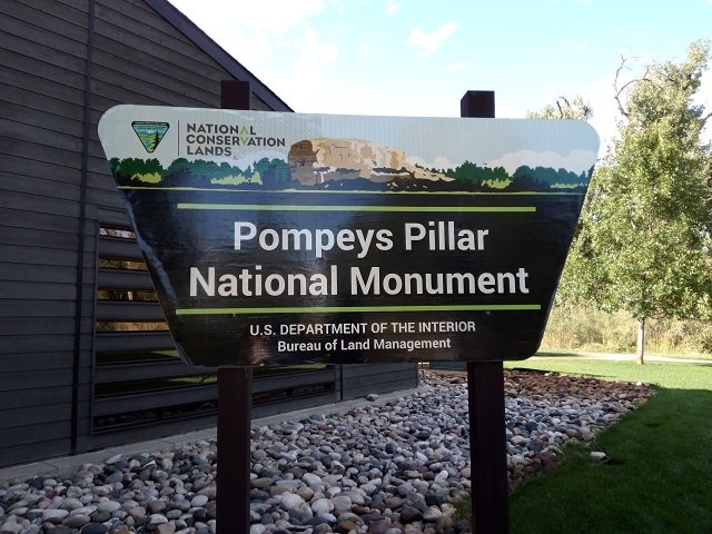
Standing 150 feet above the Yellowstone River in Southern Montana and consisting of sandstone from the late Cretaceous Hell Creek Formation, 75 – 66 million years ago, is Pompeys Pillar National Monument. While we were staying in the area to see family, and being related to John Colter of the Lewis and Clark expedition, we made sure to check it out one evening. Although perhaps best known for the inscription left behind by William Clark of the expedition, this site boasts the markings of thousands of years of human occupation. I will share more about the monument in a minute, but first want to share a little about the interpretive center.

Pompeys Pillar National Monument - Tepee

The Pompeys Pillar Interpretive Center opened in 2006. Exhibits in the 5,700-square foot center relate the journey of Captain William Clark and his detachment, including Sacagawea and her son Pomp, down the Yellowstone River Valley in 1806. The center also addresses native culture, flora and fauna, the Lewis and Clark Expedition, and the historical legacy of Pompeys Pillar through the changes of the 1800s. A number of J.K. Ralston paintings and sketches are on permanent display.

Pompeys Pillar National Monument - Statue of Clark

We enjoyed walking around and checking out some of their exhibits. Of course, you can’t miss the huge tepee right out front. As you make your way inside the center you will find a bronze sculpture of William Clark between a US and Montana flag. I enjoyed reading about Sacagawea and her son on one of the displays. Another cool thing to see was a canoe on the grounds.

Pompeys Pillar National Monument - Canoe

For a little bit of history about the Lewis and Clark expedition and Pompeys Pillar National Monument from the Friends of Pompeys PIllar:  On July 3, 1806, after crossing the Continental Divide, the Corps split into separate groups so Lewis could explore the Marias River. Lewis and Clark stayed separated until they reached the confluence of the Yellowstone and Missouri Rivers. During their separation, Captain William Clark visited Pompeys Pillar on July 25, 1806.

Pompeys Pillar National Monument - View 1

On July 25, in Clark’s group, the nine floaters noticed a huge sandstone rock “200 feet high and 400 paces in circumference” not far from the river.  Clark climbed it and saw “Emence herds of Buffalows, Elk and wolves.” Indian pictographs were on the rock, and to them he added his name and the date: Wm. Clark, July 25, 1806.  He named the rock Pompy’s Tower (now called Pompeys Pillar) after Sacagawea’s baby, whom she carried on a cradleboard strapped to her back for the 14 months that she accompanied and aided the expedition.

Pompeys Pillar National Monument - Sacagwea

In Clark’s own words, “…at 4 P.M. arrived at a remarkable rock Situated in an extensive bottom on the Start.  Side of the river & 250 paces from it.  This rock I ascended and from it’s top had a most extensive view in every direction.  This rock which I shall Call Pompy’s Tower is 200 feet high and 400 paces in secumphrance….”

Pompeys Pillar National Monument - Signature

He also described the view from atop “Pompy’s Tower”: From the top of this Tower I could discover two low Mountains & the Rocky Mts. Covered with Snow S W. One of them appeared to be extencive and bore S. 15° E. about 40 miles. The other I take to be what the Indians Call the Little wolf Mtn. I can only see the Southern extremity of it which bears N 55° about 35 Miles. The plains to the South rise from the distance of about 6 miles the width of the bottom gradually to the mountains in that derection. A large Creek with an extencive Vally the direction of which is S. 25° E. meanders boutifully through this plain.

Pompeys Pillar National Monument - Center

Today, a boardwalk leads to Capt. Clark’s signature and to the top of the Pillar, which is the last physical evidence of the Lewis and Clark Expedition. You also get a great view of the Interpitve center from the top.  As I said earlier, trails lead visitors past a replica of Captain Clark’s canoes and to a view of the 670-mile-long Yellowstone River.

Pompeys Pillar National Monument - Us

We made our way up a whole bunch of steps and I couldn’t help but think what it would have been like for Clark’s team without the stairs, and with all their gear. Wow, was all I could think when we did get to the top. It was beautiful, and you could see so for miles it seemed. Also impressive was being able to see where Clark inscribed his name and date. We took a few pictures, but mostly just sat and enjoyed the views until it started getting dark.  We headed back down with a little more knowledge about the area, and great memories.

Pompeys Pillar National Monument - Signature 2

Have you been to see Pompeys Pillar National Monument? If so, let me know what you thought about your visit. If you haven’t been, I would highly suggest a visit while in the Billings area. Happy travels.

Pompeys Pillar National Monument Visitor Information

Address:

3039 US Highway 312 Pompeys Pillar, MT 59064

Phone:

406-896-5013

Hours & Fees:

When the Monument is open (see below for season and hours), a $7 standard fee is charged for each vehicle. There is no separate fee for the interpretive center.  All valid federal recreation passes are honored at the site.

Private Vehicle Standard Fee

Rates are based on number of passengers.

6 passengers and under–$7

7-25 passengers–$12

26+ passengers–$20

2023 Season/Hours

May 1 through September 30

Main Gate: 8:30 a.m. to 4:30 p.m.

Interpretive Center Hours:

  • May-September: 9 a.m. to 4 p.m. daily

Commercial/Group Vehicle Fees

Commercial group rates are based on vehicle capacity.

Vehicles capable of seating 6 passengers and under–$25

Vehicles capable of seating 7-25 passengers–$40

Vehicles capable of seating 26+ passengers–$100

Directions:

The area is easily accessible from Interstate 94, using exit 23, or from State Highway 312. The monument is 25 miles east of Billings, Montana

Accessibility

The interpretive center, restrooms, parking lot and day use area are fully accessible.

Pets

Pets must be on a leash at all times.

West Virginia State Capitol in Charleston – The Mountain State

West Virginia State Capitol - Front

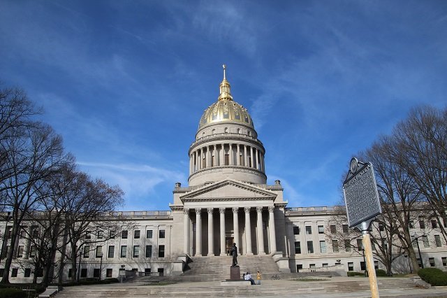
We finally made it to our 45th state and a new capitol in the city of Charleston, West Virginia! We were there late in the day so there wasn’t a whole lot going on. However we were still able to do a self-guided tour and learn a little bit about the building and its history.

West Virginia State Capitol - Flag with Gene

I will start with a bit of that history. The West Virginia State Capitol building is actually the third for the state, and was officially dedicated on June 20th, 1932 by their current Governor William B. Conley happily on the state’s 69th birthday. What a day that must have been. It had taken 8 years, and three construction projects before it was ready for public usage. The west wing was built first between 1924 and 1925. Once that was finished, the east wing was constructed in 1926 and 1927. Between 1930 and 1932 the rotunda was completed which connected the west and east wings.

West Virginia State Capitol - Dome

Atop the capitol is the 293-foot gold dome which is stated to be five feet taller than the dome of the United States Capitol.  Either way, it is covered in copper and gold leaf, and was originally gilded by Mack Jenney and Tyler Company in 1931. The dome was later restored to the original plans of Cass Gilbert in 2005, which included the reconstruction of the eagle at the top of a 25-foot bronze spire built on a 34 and a half-foot lantern.

Rotunda

West Virginia State Capitol - Chandeller

Most rotundas in the state capitols are amazing, and this state house was no exception. Suspending 180 feet from the floor of the building on a 54-foot brass and bronze chain is a 4000-pound chandelier. It is made of 10,000 pieces of Czechoslovakian crystal, is eight feet in diameter, and is illuminated by 96 light bulbs. It is quite impressive.

West Virginia State Capitol - Us Inside

I love marble and was also impressed with how much of it was at the West Virginia State Capitol. They state the two thirds of the interior consist of marble. The walls are made of Imperial Danby, and the floors are a combination of white Vermont marble and dark Italian travertine. It was very beautiful. I think it even had more marble than the South Dakota State Capitol in Pierre.

Ground Floor

West Virginia State Capitol - Rotunda1

On the first floor of the west wing side of the capitol you will find the Governor’s Offices, the Governor’s Reception room, as well as the Secretary of State’s Offices. On the east side, you will find the Attorney General offices, the Agriculture Commissioner office, as well as the Bill Drafting and Legislative Services office.

Second Floor

West Virginia State Capitol - Chambers

On the west wing side of the building you will find the Senate Chamber, the Senate Majority leader’s office, and many other Senate related offices. On the east wing side of the capitol you will find the House of Delegates Chamber, the House Speaker’s office, the House Majority Leaders office, as well as many House related offices. Couple of interesting things to note, that while the chambers are similar, there are quite a few specific differences. Two rows of coffers grace the arches above the Senate chamber, while the House has only one. There are carved eagles in each of the chambers which are also a little different. The ones in the Senate have their wings spread, while the ones in the House are closed. Another unique difference between the two chambers is their ceilings. The Senate is dome shaped, while the one in the House is flat.

West Virginia State Capitol - Side

I was very happy to be able to see and explore the West Virginia State Capitol. I have to say we had a nice time walking around the building while getting a little turned around at times, lol (it is actually WAY bigger than it looks) but everyone we spoke with was very friendly and quick to answer any questions we had.

West Virginia State Capitol - Gardens

However, a tour is not complete without checking out some of the statues on the Capitol Grounds.  Below is a list of some of these statues you might like to see:

  • West Virginia Veterans Memorial
  • The West Virginia Female Veterans statue
  • Spirit of West Virginia
  • Booker T. Washington
  • The Liberty Bell
  • Mountaineer Solder
  • “Stonewall” Jackson
  • Abraham Lincoln Walks at Midnight
  • Soldiers and Sailors Monument
  • The Coal Miner Statue

West Virginia State Capitol Visitor Information

Address:

1900 Kanawha Boulevard East Charleston, West Virginia

Phone:

304- 558-4839

Hours:

The Capitol is open from 8 a.m. to 5:30 p.m. Monday – Friday, 9 a.m. to 5:30 p.m. Saturday and 12 p.m. to 5:30 p.m. Sunday and Holidays.

Price:

Free

Tours:

State Capitol tours, and tours of the Governor’s Mansion are available for guests, school groups, etc., by calling Capitol Tours & Information – (304) 558-4839

Individuals and groups may also tour the nearby Culture Center and West Virginia State Museum – (304) 558-0220

Directions:

From points North: Take I-77 South to the Greenbrier Street/ State Capitol Exit (Exit 99), turn right off the exit ramp onto Greenbrier Street, then turn left at Washington Street into the State Capitol parking lot.

From points East: Take I-68 West to I-79 South, then to I-77 South. Take the Greenbrier Street/ State Capitol Exit (Exit 99), turn right off the exit ramp onto Greenbrier Street, then turn left at Washington Street into the State Capitol parking lot.

From points South: Take I-77 North to the Greenbrier Street/ State Capitol Exit (Exit 99), turn left off the exit ramp onto Greenbrier Street, then turn left at Washington Street into the State Capitol parking lot.

From points West: Take I-64 East to the Greenbrier Street/ State Capitol Exit (Exit 99), turn right off the exit ramp onto Greenbrier Street, then turn left at Washington Street into the State Capitol parking lot.

Parking & Shuttle:

Shuttle service is provided between the Capitol Complex and the Laidley Field parking area in three shifts, a morning shift, a midday shift and an afternoon shift. The shuttle departs from Laidley Field starting at 6:45 a.m. All other shifts the shuttle starts at Building 3. The last run of the day begins at 5:15 p.m. Each complete run of the shuttle is approximately 10-15 minutes depending on traffic lights and traffic.

The shuttle does not operate typically between 9:30 a.m.-11:30 a.m. and 1:45 p.m.-3:00 p.m. The Schedule also includes a number to call if more information or assistance is needed. The stops include: Laidley Field, Capitol Parking Garage {North Side}, Building 3 {North Side}, Building 5, Building 6, Capitol Building East Wing, Capitol Building West Wing & Cultural Center Entrances. The shuttle bus is handicapped accessible.

Accessibility:

All public entrances to the State Capitol are wheel chair accessible.

Food:

The Capitol Complex Food Court is located in the basement of the main capitol building. It is open Monday-Friday – 7:00am – 1:30pm. Menus, contact information and more are available through the Food Court’s website: https://www.wvcapitolfoodcourt.com/