
As those of you who have followed my blog for a while, you probably know I really loved bridges. Not sure exactly why I do, but I do, lol. Today I want to share some information and pictures about the beautiful Mackinaw Bridge. We were able to travel across it while in the Upper Peninsula of Michigan for our anniversary in May of this year. I had heard of this bridge for many years, and couldn’t wait to see it in person. It didn’t disappoint J It is/was beautiful. Before I tell you a little bit about our visit, let me give you some history about the bridge itself.
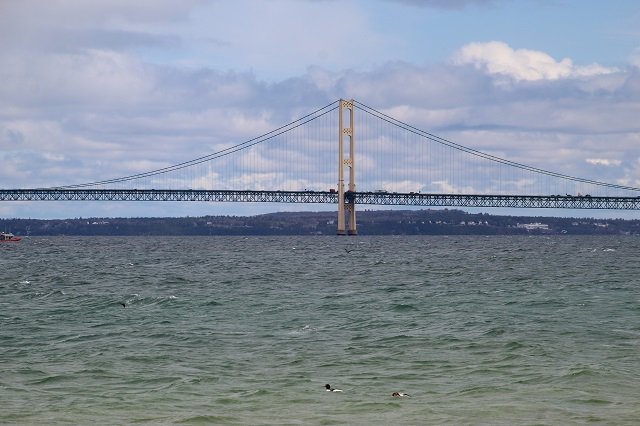
 I will start by sharing that it is a suspension bridge that spans the Straits of Mackinaw. It connects the Upper and Lower Peninsula’s of Michigan and opened on November 1, 1957. Formally known as “Big Mac”, it is 26,372 feet long and is the world’s 24th longest main span bridge and the longest suspension bridge in the Western Hemisphere. It is a truly amazing sight to see and travel on, which we did while traveling from Mackinaw City on the south end to the north end village of St. Ignace. Technically it is part of interstate 75 (I-75) and part of the Great Lakes Circle Tour. The best part is that on one side is Lake Michigan and on the other side is Lake Huron. That still amazes and shocks me, but not sure why, lol.
 With mineral and timber recourses increasing during the 19th century, the railroads that serviced the Straits, the Michigan Central, Grand Rapids & Indiana, and the Detroit, Mackinac & Marquette, jointly established the Mackinac Transportation Company in 1881. This new company was brought to life to operate a railroad car ferry service across the straits and connect the two peninsulas.
 In the 20th century with highways being established it brought much automobile traffic to the Straits. Thus Michigan started an automobile ferry service between Mackinaw City and St. Ignance in 1923. It was so busy and popular that they would fun nine ferries a day and would carry as many as 9,000 vehicles per day. There were reports of backups stretching as long as 16 miles to get on a ferry. Sounds crazy to me.
 While the bridge was needed and wanted since the early 1880s, (especially after the building of the Brooklyn Bridge) it wasn’t designed until 1953 or completed until 1957 by engineer David B Steinman. That was a long time for a need or desire to become a reality, but there were some delays was due to the unique engineering challenge created by the tremendous forces against the base of the bridge, plus the fact that the lakes freeze during the winter which would place even more stress on the bridge. On top of that, it was put on hold due to World War II.
 The aforementioned engineer David B Steinman designed the plans for the bridge and construction started on May 7, 1954. The process took three and a half years (four summers, no winter construction) at a total cost of $100 million and the lives of five workers. Also stated earlier, to the joy of many who lived or traveled to the area, the Mackinaw Bridge opened to traffic on November 1, 1957, and the ferry service was discontinued on the same day. On June 25, 1958, the new Mackinaw Bridge was formally dedicated.
 Mackinaw Bridge Facts:
 Mackinaw Bridge Facts:
- Length from cable bent pier to cable bent pier: 7,400 feet (2,256 m)
- Total width of the roadway: 54 feet (16.5 m)
- Two outside lanes: 12 feet (3.7 m) wide each
- Two inside lanes: 11 feet (3.4 m) wide each
- Center mall: 2 feet (0.61 m)
- Catwalk, curb, and rail width: 3 feet (0.91 m) on each side
- Width of stiffening truss in the suspended span: 68 feet (20.7 m)
- Depth of stiffening truss: 38.1 feet (11.6 m)
- Height of the roadway at mid-span: approximately 200 feet (61 m) above water level
- Vertical clearance at normal temperature:
- 155 feet (47 m) at the center of the main suspension span.
- 135 feet (41 m) at the boundaries of the 3,000-foot-wide (914 m) navigation channel.

- Height of towers above water: 552 feet (168 m)
- Max. depth of towers below water: 210 feet (64 m)
- Depth of water beneath the center of the bridge, 250 feet (76 m)
- Main cables:
- Number of wires in each cable: 12,580
- Diameter of each wire: 0.196 inches (0.498 cm)
- Diameter of each cable: 24.5 inches (62.23 cm)
- Total length of wire in main cables: 42,000 miles (68,000 km).
- Total vehicle crossings, 2005: 4,236,491 (average 11,608 per day)
- Speed limit: 45 miles per hour (72 km/h) for passenger cars, 20 miles per hour (32 km/h) for heavy trucks. Heavy trucks are also required to leave a 500-foot (150 m) spacing ahead.
- The current toll is $4 for automobiles and $5 per axle for trucks.
 No matter which side of the Peninsula you are on, there are great views of the Mackinaw Bridge for you to gaze upon. You paid the toll, you might as well take the time and make sure to check out both sides. They are both beautiful. One side even has a memorial to 5 men who died while building the bridge. One word of advice, make sure to bring bug spray as the bugs were out in full force during our visit. Just little annoying nats, but they did bite and it was not fun. Other than that, we had a wonderful time checking out this amazing bridge. If you haven’t seen it, I hope you get to one day in the future. Here is a link to their website with more information and current bridge conditions

LIKE WHAT YOU ARE READING?

I would love to send you my free travel itinerary cheat sheets and emails when I post new articles! I usually post 2 times a week. Sign up now, receive your free travel sheets, and don’t miss an article. Thanks, Samantha


This post was created using WordPress. Create your own site for FREE!
Great post. I love bridges, too, and I think I can list a few reasons why:
1. They usually display beautiful architecture / design
2. They literally connect two parties or cities. Countries even in your case.
3. They make your life easier because otherwise you’d have to drive miles and miles.
I had to go back to my own pictures because I remember having gone from Detroit to Canada. However, it was the Ambassador Bridge.
Thanks for the msg Tamara. I think I also love them because a lot of times they have water on both sides, and I love that 🙂 Thanks again for sharing and stating why you like them. I did a tour in Oregon of 9 really old covered bridges and can’t wait to work on it and share. I will let you know when I do.
We used to have many covered bridges in Lancaster County, PA. Only a few are left, sad to say. They were destroyed by development, which adds to the sadness. I love the pictures here.
I like to look at bridges. The designs are truly amazing. But they are not my favorite thing, unless they are smaller, pedestrian friendly bridges. And because I don’t have a car but do have a great fear of heights, they don’t improve my life at all. But, anyway, that was an interesting and informative and well research blog post. Great job.
Heya! I’m a Michigander and lived within an hour of the bridge for 13 years and still only drove over it a few times LOL! I spent more time looking at it from land than crossing over it 😉 Thanks for sharing so many juicy facts.
HI Kelly, you are welcome and thank you for stopping by and leaving a message. 🙂